

FSWidgets iGMap app for iPhone and iPad
Developer: Fermin Fernandez
First release : 06 Jul 2010
App size: 11.26 Mb
The FSWidgets iGMap app turns your iPhone or iPod touch into a moving map for your desktop flight simulator!
(See iGMapHD for the iPad Version)
Do you own MSFS, FSX, FS9, X-Plane or Aerofly FS 2?
This app works with the three most popular desktop simulators on the market today, giving you a hand-held moving map to aid navigation, especially on simulated VFR flights.
It connects to the flight simulator via our free FSWidgets Network Pack which can be downloaded from the FSWidgets website (http://fswidgets.com/shop/network.php).
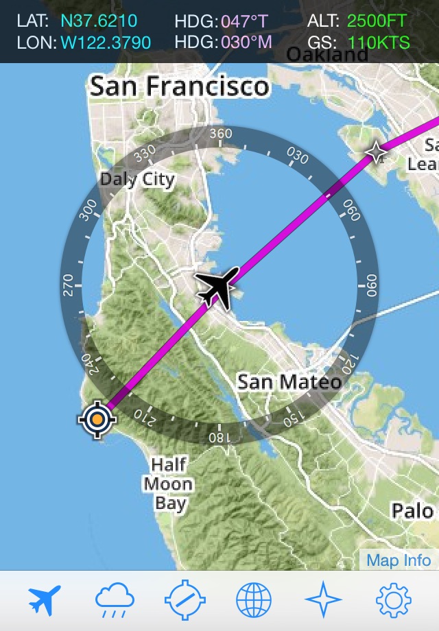
iGMap saves valuable screen real-estate on your desktop by using your iPhone or iPod Touch to display your aircrafts current position.
GENERAL FEATURES:
▸ Connects to MSFS, FSX, FS9, X-Plane and Aerofly FS 2.
▸ Flight Plan Display - supports MSFS, FSX, FS9 and X-Plane flight plan files.
▸ Flight Plan file import via iTunes > Device Apps tab > File Sharing.
▸ Flight Plan file import via Dropbox.
▸ Waypoints can be tapped to reveal the related data (e.g. lat, lon, ident, dist, heading).
▸ FSWidgets Network Pack provided free (see the website link).
▸ Connect & disconnect from the flight simulator as required.
▸ When disconnected can be used as a chart viewer.
▸ Map supports drag to pan and pinch to zoom.
▸ Option to remember previously used map type, zoom and position, or accept default settings.
▸ Helicopter icon option for moving map (i.e. instead of fixed wing icon).
MAPPING FEATURES:
▸ Map powered by Leaflet API (using OpenStreetMap & custom data)
▸ Includes various world-wide maps styles
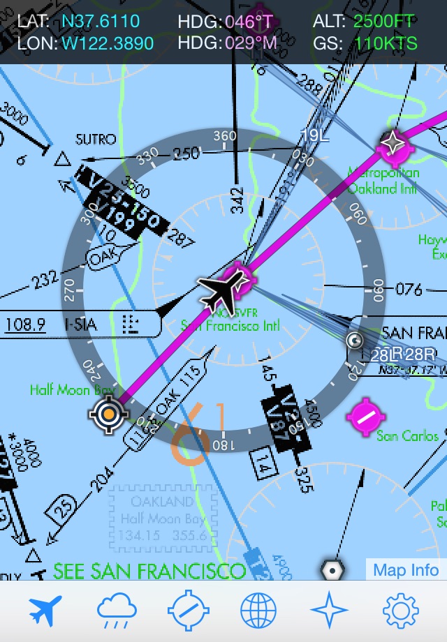
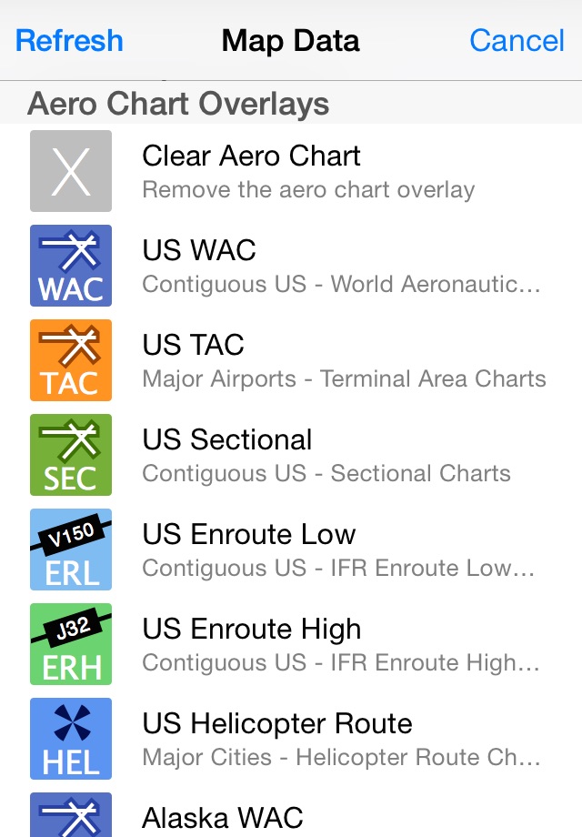
▸ Huge collection of Aero Charts (as follows):
- US WAC (World Aeronautical Chart) data, covers entire contiguous US & Hawaii.
- US SEC (Sectional Chart) data, covers entire contiguous US.
- US TAC (Terminal Area Charts) data.
- US IFR Enroute Low data, covers entire contiguous US.
- US IFR Enroute High data, covers entire contiguous US.
- US Helicopter Route (9 Major cities).
- US VFR Wall Planner
- US IFR Planning Chart
- Alaska WAC data.
- Alaska Sectional data.
- Alaska Enroute Low
- Alaska Enroute High
- Cuba and Puerto Rico WAC data.
- Canada ONC.
- New Zealand Aero Chart.
- New Zealand TPC
- Australia ONC (Operational Navigation Chart).
- South America ONC.
- Europe ONC.
- Europe TPC (Tactical Pilotage Charts)
- Spain Enroute Low
- Belgium Aero OFM (open flightmaps)
- Netherlands Aero OFM
- Denmark Aero OFM
- Sweden Aero OFM
- Germany Aero OFM
- Switzerland Aero OFM
- Austria Aero OFM
- Poland Aero OFM
- Czech Republic Aero OFM
- Hungary Aero OFM
- Slovenia Aero OFM
- Croatia Aero OFM
- Romania Aero OFM
- Bulgaria Aero OFM
- World-wide Navigational icon info display (airport, VOR, NDB, ILS).
WEATHER FEATURES:
▸ Metar and TAF info icon display.
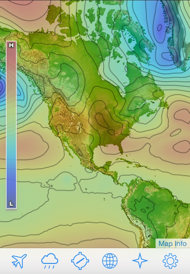
▸ Worldwide weather overlays (Cloud, Rain, Pressure & Wind).
▸ US Nexrad (Next-Gen Radar) overlay.
REQUIREMENTS:
▸ iPhone with iOS 11.0 or later.
▸ MSFS, FSX, FS9, X-Plane or Aerofly FS 2.
▸ Free FSWidgets Network Pack must be installed to connect to simulator - download from FSWidgets (see the website link).
▸ Wi-Fi network required, iPad must be on same local network as machine running the flight simulator.
▸ Internet access required, to automatically download map tile data on the fly.
WHO WE ARE:
FSWidgets is a software development team based in Australia, specializing in add-ons for Microsoft Flight Simulator (Windows), Laminar Research X-Plane and Aerofly FS 2. Both of its founding members have extensive experience in creating award-winning add-ons for Flight Simulator and have been active in the flight simulation community for well over a decade.
SUPPORT:
Personalized and friendly support can be found via our contact form (http://fswidgets.com/shop/contact_us.php) or our support email ([email protected]).
UPDATES:
Future updates and additional features added to iGMap will be free for existing customers.